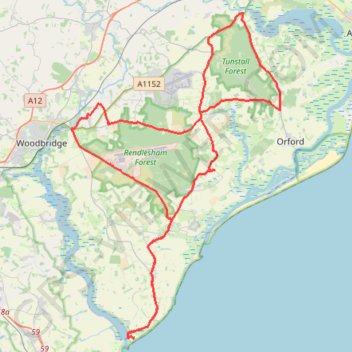
Tunstall Forest and Rendlesham Forest Loop from Bawdsey Manor
- Distance: 40.5 mi
- Elevation gain: 1,322 ft
- Maximum elevation: 112 ft
- Elevation loss: 1,322 ft
- Minimum elevation: -3 ft
- Moving time: 2 h 35 m
- Moving speed: 15.7 mph
- Maximum speed: 25.4 mph
- Total time: 2 h 57 m
- Global speed: 13.7 mph
Interactive trail map
Trail profile
- Distance: 40.5 mi
- Elevation gain: 1,322 ft
- Maximum elevation: 112 ft
- Elevation loss: 1,322 ft
- Minimum elevation: -3 ft
- Moving time: 2 h 35 m
- Moving speed: 15.7 mph
- Maximum speed: 25.4 mph
- Total time: 2 h 57 m
- Global speed: 13.7 mph
About this trail
Name: Tunstall Forest and Rendlesham Forest Loop from Bawdsey Manor trail, distance, elevation, map, profile, GPS track
Coordinates: 51.99001 1.34612 52.16264 1.52613
Other hiking, mountain biking, running and outdoor activity trails
Click on a trail to view its statistics, map and profile.
Shottisham - Aldertom - Shingle Street - Hollesley - Shottisham
United Kingdom > England > Suffolk > East Suffolk > Shottisham
Distance: 11.3 mi • Elevation gain: 302 ft • Maximum elevation: 79 ft
Suffolk Coastal Trail Running
United Kingdom > England > Suffolk > East Suffolk > Hollesley
Woodbridge
Distance: 13.7 mi • Elevation gain: 387 ft • Maximum elevation: 92 ft
Dunwich to Aldborough loop ride
United Kingdom > England > Suffolk > East Suffolk > Dunwich
Distance: 36.2 mi • Elevation gain: 1,155 ft • Maximum elevation: 135 ft
Walk to Saxmundham
United Kingdom > England > Suffolk > East Suffolk > Campsea Ashe
Distance: 11.1 mi • Elevation gain: 315 ft • Maximum elevation: 98 ft