Make a donation
Gear up for your next adventure:
As an Amazon Associate, this site earns from qualifying purchases at no extra cost to you.
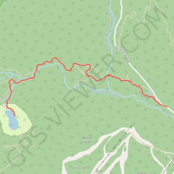
Lost Lake
Interactive trail map
Make a donation
Gear up for your next adventure:
As an Amazon Associate, this site earns from qualifying purchases at no extra cost to you.
Trail profile
- Distance: 4.0 mi
- Elevation gain: 846 ft
- Maximum elevation: 9,803 ft
- Elevation loss: 846 ft
- Minimum elevation: 8,967 ft
Make a donation
Gear up for your next adventure:
As an Amazon Associate, this site earns from qualifying purchases at no extra cost to you.
About this trail
Name: Lost Lake trail, distance, elevation, map, profile, GPS track
Start: Fourth Of July Road, Boulder County, Colorado, 80474, United States (39.95133 -105.59408)
End: Fourth Of July Road, Boulder County, Colorado, 80474, United States (39.95133 -105.59408)
Coordinates: 39.95033 -105.61733 39.95680 -105.59408
Topography: Boulder County topographic map, elevation, terrain
Make a donation
Gear up for your next adventure:
As an Amazon Associate, this site earns from qualifying purchases at no extra cost to you.
Other hiking, mountain biking, running and outdoor activity trails
Click on a trail to view its statistics, map and profile.
Lost Lake from Hessie Trailhead via Devil's Thumb Trail in Roosevelt National Forest
United States > Colorado > Boulder County
This trail offers a pleasant walk through forested terrain, with the steady sound of a nearby creek and a few waterfalls to enjoy along the way. The slightly uphill trail leads to Lost Lake, a peaceful spot that's perfect for a break before heading back. #Hiking #Mountain #Lake #River #Waterfall #Forest #Nature
Distance: 4.4 mi • Elevation gain: 879 ft • Maximum elevation: 9,820 ft