Thank you for supporting this site ❤️
Make a donation
Make a donation
Gear up for your next adventure:
As an Amazon Associate, this site earns from qualifying purchases at no extra cost to you.
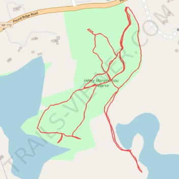
Henry Morgenthau Preserve trails
- Distance: 2.0 mi
- Elevation gain: 164 ft
- Maximum elevation: 558 ft
- Elevation loss: 164 ft
- Minimum elevation: 476 ft
- Moving time: 44 m 3 s
- Moving speed: 2.7 mph
- Maximum speed: 5.6 mph
- Total time: 52 m 19 s
- Global speed: 2.3 mph
Interactive trail map
Thank you for supporting this site ❤️
Make a donation
Make a donation
Gear up for your next adventure:
As an Amazon Associate, this site earns from qualifying purchases at no extra cost to you.
Trail profile
- Distance: 2.0 mi
- Elevation gain: 164 ft
- Maximum elevation: 558 ft
- Elevation loss: 164 ft
- Minimum elevation: 476 ft
- Moving time: 44 m 3 s
- Moving speed: 2.7 mph
- Maximum speed: 5.6 mph
- Total time: 52 m 19 s
- Global speed: 2.3 mph
Thank you for supporting this site ❤️
Make a donation
Make a donation
Gear up for your next adventure:
As an Amazon Associate, this site earns from qualifying purchases at no extra cost to you.
About this trail
Name: Henry Morgenthau Preserve trails trail, distance, elevation, map, profile, GPS track
Coordinates: 41.19648 -73.59148 41.20134 -73.58740
Topography: Westchester County topographic map, elevation, terrain
Thank you for supporting this site ❤️
Make a donation
Make a donation
Gear up for your next adventure:
As an Amazon Associate, this site earns from qualifying purchases at no extra cost to you.
Other hiking, mountain biking, running and outdoor activity trails
Click on a trail to view its statistics, map and profile.