Make a donation
Gear up for your next adventure:
As an Amazon Associate, this site earns from qualifying purchases at no extra cost to you.
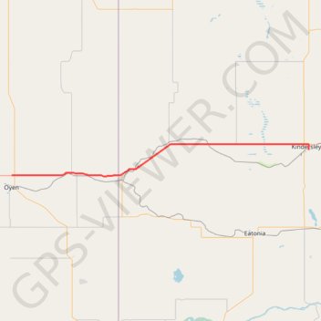
Oyen - Kindersley
#Bike #Oyen #Kindersley
- Distance: 60.8 mi
- Elevation gain: 1,030 ft
- Maximum elevation: 2,536 ft
- Elevation loss: 1,332 ft
- Minimum elevation: 2,221 ft
Interactive trail map
Make a donation
Gear up for your next adventure:
As an Amazon Associate, this site earns from qualifying purchases at no extra cost to you.
Trail profile
- Distance: 60.8 mi
- Elevation gain: 1,030 ft
- Maximum elevation: 2,536 ft
- Elevation loss: 1,332 ft
- Minimum elevation: 2,221 ft
Make a donation
Gear up for your next adventure:
As an Amazon Associate, this site earns from qualifying purchases at no extra cost to you.
About this trail
Name: Oyen - Kindersley trail, distance, elevation, map, profile, GPS track
Start: Highway 9, Special Area No. 3, Alberta, T0J 2J0, Canada (51.38707 -110.48271)
Coordinates: 51.38402 -110.48271 51.47493 -109.14477
Make a donation
Gear up for your next adventure:
As an Amazon Associate, this site earns from qualifying purchases at no extra cost to you.
Other hiking, mountain biking, running and outdoor activity trails
Click on a trail to view its statistics, map and profile.
Kindersley - Rosetown
Canada > Saskatchewan > Kindersley
Distance: 53.4 mi • Elevation gain: 604 ft • Maximum elevation: 2,293 ft