Import a GPX file

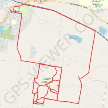
Gatton National Park

#MTB #Loop #Gatton

  • Distance: 28.5 mi
  • Elevation gain: 2,146 ft
  • Maximum elevation: 689 ft
  • Elevation loss: 2,149 ft
  • Minimum elevation: 289 ft

Interactive trail map

Trail profile

  • Distance: 28.5 mi
  • Elevation gain: 2,146 ft
  • Maximum elevation: 689 ft
  • Elevation loss: 2,149 ft
  • Minimum elevation: 289 ft

About this trail

Other hiking, mountain biking, running and outdoor activity trails

Click on a trail to view its statistics, map and profile.

Goomburra - Gatton

Australia > Queensland

Main Range National Park. #MTB #MainRange

Distance: 47.5 mi • Elevation gain: 3,848 ft • Maximum elevation: 3,196 ft

Gear up for your next adventure:

🧺Microfiber Travel Towels - Compact and fast-drying towels for trail use
🧦Hiking Socks - Comfortable socks to prevent blisters on long hikes
🔪Outdoor Multitools - Essential survival tools for gear repair and field use
🪶Trail Camera - Capture wildlife on your hikes
🌡️Handheld Weather Meters - Measure wind, temp, and pressure for safe mountain travel

As an Amazon Associate, this site earns from qualifying purchases at no extra cost to you.