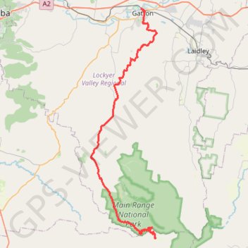
Goomburra - Gatton
Interactive trail map
Trail profile
- Distance: 47.5 mi
- Elevation gain: 3,848 ft
- Maximum elevation: 3,196 ft
- Elevation loss: 5,627 ft
- Minimum elevation: 325 ft
About this trail
Name: Goomburra - Gatton trail, distance, elevation, map, profile, GPS track
End: Railway Street, Gatton, Lockyer Valley Regional, Queensland, 4343, Australia (-27.55587 152.27732)
Coordinates: -27.97561 152.17299 -27.55540 152.30891
Other hiking, mountain biking, running and outdoor activity trails
Click on a trail to view its statistics, map and profile.
Warwick - Gatton
Australia > Queensland > Warwick
#Bike
Distance: 77.8 mi • Elevation gain: 2,664 ft • Maximum elevation: 1,909 ft
Walk to Glen Rock, QLD
Distance: 3.1 mi • Elevation gain: 1,519 ft • Maximum elevation: 2,582 ft
Black Duck
Distance: 8.7 mi • Elevation gain: 2,028 ft • Maximum elevation: 1,470 ft
Black Duck
Distance: 28.4 mi • Elevation gain: 2,057 ft • Maximum elevation: 1,867 ft