Make a donation
Gear up for your next adventure:
As an Amazon Associate, this site earns from qualifying purchases at no extra cost to you.
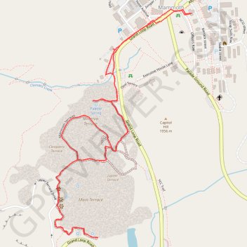
Mammoth Hot Springs Loop
Starting near the Albright Visitor Center in Yellowstone National Park, this loop follows Grand Loop Road toward Palette Spring, where steaming runoff, warm mineral colors and open views introduce the Mammoth Hot Springs landscape.
The route then crosses the Mammoth Terraces through Jupiter Terrace, Mound Terrace, Cleopatra Terrace and Main Terrace, revealing pale travertine shelves, sculpted limestone steps and shifting thermal activity across the hillside.
After continuing toward New Blue Spring, Cupid Spring, Dryad Spring and Canary Spring, the walk returns toward the Mammoth area and makes a final detour to Minerva Terrace before finishing back near the Albright Visitor Center.
#Hiking #Loop #Nature #Mountain #Volcano #Yellowstone #Thermal #Springs
- Distance: 2.8 mi
- Elevation gain: 430 ft
- Maximum elevation: 6,591 ft
- Elevation loss: 430 ft
- Minimum elevation: 6,243 ft
- Moving time: 2 h 54 m
- Moving speed: 1.0 mph
- Maximum speed: 2.6 mph
- Total time: 5 h 24 m
- Global speed: 0.5 mph
Interactive trail map
Make a donation
Gear up for your next adventure:
As an Amazon Associate, this site earns from qualifying purchases at no extra cost to you.
Trail profile
- Distance: 2.8 mi
- Elevation gain: 430 ft
- Maximum elevation: 6,591 ft
- Elevation loss: 430 ft
- Minimum elevation: 6,243 ft
- Moving time: 2 h 54 m
- Moving speed: 1.0 mph
- Maximum speed: 2.6 mph
- Total time: 5 h 24 m
- Global speed: 0.5 mph
Make a donation
Gear up for your next adventure:
As an Amazon Associate, this site earns from qualifying purchases at no extra cost to you.
About this trail
Name: Mammoth Hot Springs Loop trail, distance, elevation, map, profile, GPS track
Start: Mammoth Hotel Avenue, Cabins, Mammoth, Park County, Wyoming, United States (44.97601 -110.70133)
End: Grand Loop Road, Mammoth, Park County, Wyoming, United States (44.97602 -110.70138)
Coordinates: 44.96678 -110.70771 44.97654 -110.69947
Topography: Park County topographic map, elevation, terrain
Make a donation
Gear up for your next adventure:
As an Amazon Associate, this site earns from qualifying purchases at no extra cost to you.