Import a GPX file

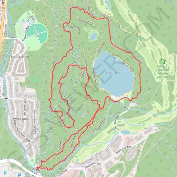
Lost Lake - Whistler

#Hiking #Loop

  • Distance: 4.6 mi
  • Elevation gain: 581 ft
  • Maximum elevation: 2,418 ft
  • Elevation loss: 581 ft
  • Minimum elevation: 2,178 ft

Interactive trail map

Trail profile

  • Distance: 4.6 mi
  • Elevation gain: 581 ft
  • Maximum elevation: 2,418 ft
  • Elevation loss: 581 ft
  • Minimum elevation: 2,178 ft

About this trail

Other hiking, mountain biking, running and outdoor activity trails

Click on a trail to view its statistics, map and profile.

Cheakamus River and Lillooet River

Canada > British Columbia > Squamish-Lillooet Regional District > Area D (Elaho/Garibaldi)

Bikepack from Daisy Lake along Cheakamus River and Lillooet River via Alta Lake, Whistler, Green Lake, Shadow Lake, Nairn Falls, One Mile Lake and Pemberton. #Bike #Nature #River #Lake #Mountain #Forest

Distance: 52.6 mi • Elevation gain: 4,045 ft • Maximum elevation: 2,474 ft

Vancouver - Golden

Canada > British Columbia > Metro Vancouver Regional District > Vancouver

#Bike #Vancouver #Golden

Distance: 514.2 mi • Elevation gain: 30,761 ft • Maximum elevation: 4,419 ft

Gear up for your next adventure:

🪶Fire Starter Kit - Reliable fire starter for survival and camping
🧴Hand Sanitizer - Keep hands clean while hiking
🍳Camping Cook Set - Complete cookware for outdoor meals
🧤Hiking Gloves - Protective gloves for rugged trails
📚Navigation Handbooks - Master the art of reading topographic maps and using a compass

As an Amazon Associate, this site earns from qualifying purchases at no extra cost to you.