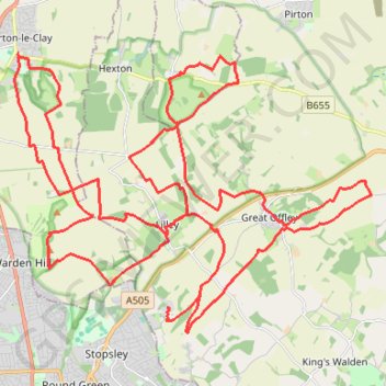
North Chilterns 50k 2022
- Distance: 31.0 mi
- Elevation gain: 2,510 ft
- Maximum elevation: 630 ft
- Elevation loss: 2,493 ft
- Minimum elevation: 233 ft
Interactive trail map
Trail profile
- Distance: 31.0 mi
- Elevation gain: 2,510 ft
- Maximum elevation: 630 ft
- Elevation loss: 2,493 ft
- Minimum elevation: 233 ft
About this trail
Name: North Chilterns 50k 2022 trail, distance, elevation, map, profile, GPS track
Coordinates: 51.90476 -0.42715 51.96389 -0.30419
Other hiking, mountain biking, running and outdoor activity trails
Click on a trail to view its statistics, map and profile.
Hitchin Outer Orbital Path (HOOP)
United Kingdom > England > Hertfordshire > North Hertfordshire > Hitchin
Distance: 11.9 mi • Elevation gain: 577 ft • Maximum elevation: 328 ft
Deacon Hill
United Kingdom > England > Hertfordshire > North Hertfordshire
Letchworth, Ickleford, Pirton, Deacon Hill and return
Distance: 16.4 mi • Elevation gain: 961 ft • Maximum elevation: 597 ft
Route
United Kingdom > England > Central Bedfordshire > Upper Sundon
Distance: 70.2 mi • Elevation gain: 2,963 ft • Maximum elevation: 558 ft