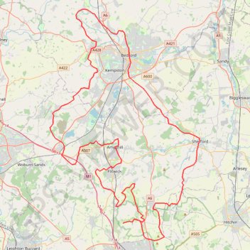
Route
- Distance: 70.2 mi
- Elevation gain: 2,963 ft
- Maximum elevation: 558 ft
- Elevation loss: 2,963 ft
- Minimum elevation: 92 ft
Interactive trail map
Trail profile
- Distance: 70.2 mi
- Elevation gain: 2,963 ft
- Maximum elevation: 558 ft
- Elevation loss: 2,963 ft
- Minimum elevation: 92 ft
About this trail
Name: Route trail, distance, elevation, map, profile, GPS track
Coordinates: 51.92538 -0.61265 52.18811 -0.33532
Other hiking, mountain biking, running and outdoor activity trails
Click on a trail to view its statistics, map and profile.
The Jo Cox Way 2022 Day 4 - Milton Keynes to Uxbridge
United Kingdom > England > City of Milton Keynes > Milton Keynes > Monkston
Distance: 64.9 mi • Elevation gain: 3,406 ft • Maximum elevation: 823 ft
The Jo Cox Way 2022 Day 3 Market Bosworth to Milton Keynes
United Kingdom > England > Leicestershire > Hinckley and Bosworth > Market Bosworth
Distance: 76.4 mi • Elevation gain: 3,127 ft • Maximum elevation: 640 ft
The JCW 23 - Cranfield to Uxbridge
United Kingdom > England > Central Bedfordshire > Cranfield
Distance: 56.0 mi • Elevation gain: 2,831 ft • Maximum elevation: 873 ft
Deacon Hill
United Kingdom > England > Hertfordshire > North Hertfordshire
Letchworth, Ickleford, Pirton, Deacon Hill and return
Distance: 16.4 mi • Elevation gain: 961 ft • Maximum elevation: 597 ft
North Chilterns 50k 2022
United Kingdom > England > Hertfordshire > North Hertfordshire > Offley > Mangrove Green
Distance: 31.0 mi • Elevation gain: 2,510 ft • Maximum elevation: 630 ft
JCW25 Day 4
United Kingdom > England > Central Bedfordshire > Cranfield
Distance: 65.8 mi • Elevation gain: 3,166 ft • Maximum elevation: 873 ft
Flitwick
United Kingdom > England > Central Bedfordshire > Flitwick
Distance: 10.3 mi • Elevation gain: 466 ft • Maximum elevation: 364 ft