Make a donation
Gear up for your next adventure:
As an Amazon Associate, this site earns from qualifying purchases at no extra cost to you.
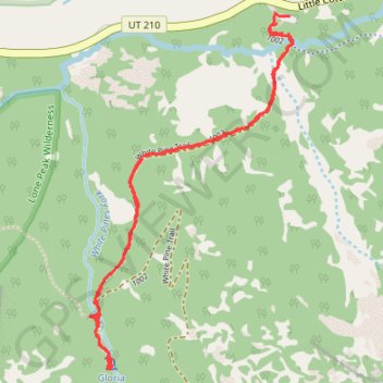
Gloria Falls
The hike to Gloria Falls takes you through a peaceful forest setting, following a well-trodden trail along a creek, with beautiful views of surrounding ridges. Though some sections are a bit rocky, the gradual incline makes it accessible for most hikers, including beginners. At the end, the trail rewards you with a stunning waterfall. #Hiking #Mountain #Waterfall #River #Forest #Nature
- Distance: 2.6 mi
- Elevation gain: 646 ft
- Maximum elevation: 8,258 ft
- Elevation loss: 630 ft
- Minimum elevation: 7,657 ft
- Moving time: 1 h 16 m
- Moving speed: 2.1 mph
- Maximum speed: 7.1 mph
- Total time: 1 h 32 m
- Global speed: 1.7 mph
Interactive trail map
Make a donation
Gear up for your next adventure:
As an Amazon Associate, this site earns from qualifying purchases at no extra cost to you.
Trail profile
- Distance: 2.6 mi
- Elevation gain: 646 ft
- Maximum elevation: 8,258 ft
- Elevation loss: 630 ft
- Minimum elevation: 7,657 ft
- Moving time: 1 h 16 m
- Moving speed: 2.1 mph
- Maximum speed: 7.1 mph
- Total time: 1 h 32 m
- Global speed: 1.7 mph
Make a donation
Gear up for your next adventure:
As an Amazon Associate, this site earns from qualifying purchases at no extra cost to you.
About this trail
Name: Gloria Falls trail, distance, elevation, map, profile, GPS track
Start: White Pine Trail, Salt Lake County, Utah, 84138, United States (40.57531 -111.68139)
Coordinates: 40.56382 -111.68960 40.57565 -111.68071
Topography: Salt Lake County topographic map, elevation, terrain
Make a donation
Gear up for your next adventure:
As an Amazon Associate, this site earns from qualifying purchases at no extra cost to you.
Other hiking, mountain biking, running and outdoor activity trails
Click on a trail to view its statistics, map and profile.