Conwy Hiking
- Distance: 11.2 mi
- Elevation gain: 696 ft
- Maximum elevation: 3,179 ft
- Elevation loss: 3,527 ft
- Minimum elevation: 23 ft
- Moving time: 3 h 53 m
- Moving speed: 2.9 mph
- Maximum speed: 4.5 mph
- Total time: 4 h 5 m
- Global speed: 2.7 mph
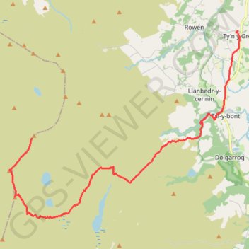
Interactive trail map
Trail profile
- Distance: 11.2 mi
- Elevation gain: 696 ft
- Maximum elevation: 3,179 ft
- Elevation loss: 3,527 ft
- Minimum elevation: 23 ft
- Moving time: 3 h 53 m
- Moving speed: 2.9 mph
- Maximum speed: 4.5 mph
- Total time: 4 h 5 m
- Global speed: 2.7 mph
About this trail
Name: Conwy Hiking trail, distance, elevation, map, profile, GPS track
Start: Melynllyn Quarry Road, Caerhun, Conwy, Wales, United Kingdom (53.19365 -3.95361)
End: Trem y Coed, Caerhun, Ty'n y Groes, Conwy, Wales, LL32 8SW, United Kingdom (53.22927 -3.83904)
Coordinates: 53.16717 -3.96615 53.22936 -3.83813
Other hiking, mountain biking, running and outdoor activity trails
Click on a trail to view its statistics, map and profile.
Hillwalk Carnedd Dafydd LLewelyn Foel-fras
United Kingdom > Wales > Conwy
Distance: 13.0 mi • Elevation gain: 4,137 ft • Maximum elevation: 3,478 ft
Ultra-Trail Snowdonia Eryri UTS 100M
United Kingdom > Wales > Gwynedd > Llanberis
Distance: 101.4 mi • Elevation gain: 31,837 ft • Maximum elevation: 3,471 ft
Back from Conwy Mountain Camp
United Kingdom > Wales > Conwy > Conwy > Conwy Marina Village
Conwy Footpaths
Distance: 5.9 mi • Elevation gain: 909 ft • Maximum elevation: 623 ft
Foel Ganol Ridge Loop Hike
United Kingdom > Wales > Gwynedd > Abergwyngregyn > Tan-y-clogwyn Cottages
Distance: 5.2 mi • Elevation gain: 1,463 ft • Maximum elevation: 1,804 ft