Back from Conwy Mountain Camp
Conwy Footpaths
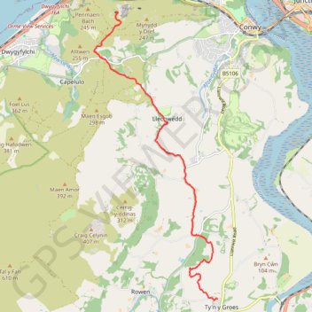
- Distance: 5.9 mi
- Elevation gain: 909 ft
- Maximum elevation: 623 ft
- Elevation loss: 955 ft
- Minimum elevation: 102 ft
- Moving time: 2 h 14 m
- Moving speed: 2.6 mph
- Maximum speed: 4.6 mph
- Total time: 2 h 23 m
- Global speed: 2.5 mph
Interactive trail map
Trail profile
- Distance: 5.9 mi
- Elevation gain: 909 ft
- Maximum elevation: 623 ft
- Elevation loss: 955 ft
- Minimum elevation: 102 ft
- Moving time: 2 h 14 m
- Moving speed: 2.6 mph
- Maximum speed: 4.6 mph
- Total time: 2 h 23 m
- Global speed: 2.5 mph
About this trail
Name: Back from Conwy Mountain Camp trail, distance, elevation, map, profile, GPS track
End: Trem y Coed, Caerhun, Ty'n y Groes, Conwy, Wales, LL32 8SW, United Kingdom (53.22926 -3.83907)
Coordinates: 53.22900 -3.87837 53.28401 -3.83907
Other hiking, mountain biking, running and outdoor activity trails
Click on a trail to view its statistics, map and profile.
Mynydd y Dref Loop
United Kingdom > Wales > Conwy > Conwy > Conwy Marina Village
Distance: 6.1 mi • Elevation gain: 1,066 ft • Maximum elevation: 787 ft
Conwy Hiking
United Kingdom > Wales > Conwy > Caerhun
Distance: 11.2 mi • Elevation gain: 696 ft • Maximum elevation: 3,179 ft
Foel Lus
United Kingdom > Wales > Conwy > Penmaenmawr
Distance: 9.6 mi • Elevation gain: 2,195 ft • Maximum elevation: 1,161 ft