Mount Cabot
Hike to Mount Cabot via York Pond Trail, Bunnell Notch Trail, Bunnell Notch, Killkenny Ridge Trail, Bunnell Rock and Mount Cabot Cabin in the White Mountain National Forest. #Hiking #Mountain #Forest #Nature
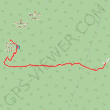
- Distance: 9.2 mi
- Elevation gain: 2,789 ft
- Maximum elevation: 4,134 ft
- Elevation loss: 2,792 ft
- Minimum elevation: 1,663 ft
- Moving time: 4 h 9 m
- Moving speed: 2.2 mph
- Maximum speed: 3.6 mph
- Total time: 4 h 35 m
- Global speed: 2.0 mph
Interactive trail map
Trail profile
- Distance: 9.2 mi
- Elevation gain: 2,789 ft
- Maximum elevation: 4,134 ft
- Elevation loss: 2,792 ft
- Minimum elevation: 1,663 ft
- Moving time: 4 h 9 m
- Moving speed: 2.2 mph
- Maximum speed: 3.6 mph
- Total time: 4 h 35 m
- Global speed: 2.0 mph
About this trail
Name: Mount Cabot trail, distance, elevation, map, profile, GPS track
Start: York Pond Trail, Berlin, Coös County, New Hampshire, United States (44.49666 -71.35891)
End: York Pond Trail, Berlin, Coös County, New Hampshire, United States (44.49651 -71.35898)
Coordinates: 44.49350 -71.41816 44.50632 -71.35891
Topography: Coos County topographic map, elevation, terrain
Other hiking, mountain biking, running and outdoor activity trails
Click on a trail to view its statistics, map and profile.