Make a donation
Gear up for your next adventure:
As an Amazon Associate, this site earns from qualifying purchases at no extra cost to you.
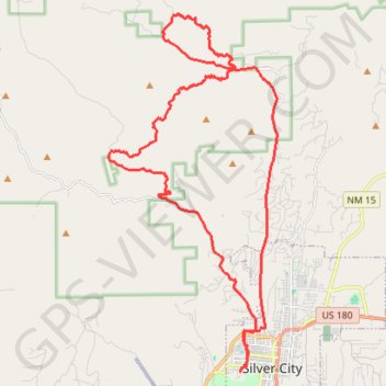
Loop around Eighty Mountain
MTB loop from Silver City at the foot of Eighty Mountain, Stewart Peak, Gomez Peak and Round Mountain in the Gila National Forest. #MTB #Loop #City #Nature #Mountain #Forest
- Distance: 25.2 mi
- Elevation gain: 2,080 ft
- Maximum elevation: 6,732 ft
- Elevation loss: 2,080 ft
- Minimum elevation: 5,938 ft
- Moving time: 2 h 40 m
- Moving speed: 9.4 mph
- Maximum speed: 25.6 mph
- Total time: 2 h 52 m
- Global speed: 8.8 mph
Interactive trail map
Make a donation
Gear up for your next adventure:
As an Amazon Associate, this site earns from qualifying purchases at no extra cost to you.
Trail profile
- Distance: 25.2 mi
- Elevation gain: 2,080 ft
- Maximum elevation: 6,732 ft
- Elevation loss: 2,080 ft
- Minimum elevation: 5,938 ft
- Moving time: 2 h 40 m
- Moving speed: 9.4 mph
- Maximum speed: 25.6 mph
- Total time: 2 h 52 m
- Global speed: 8.8 mph
Make a donation
Gear up for your next adventure:
As an Amazon Associate, this site earns from qualifying purchases at no extra cost to you.
About this trail
Name: Loop around Eighty Mountain trail, distance, elevation, map, profile, GPS track
Coordinates: 32.77004 -108.33626 32.87943 -108.27447
Topography: Silver City topographic map, elevation, terrain
Make a donation
Gear up for your next adventure:
As an Amazon Associate, this site earns from qualifying purchases at no extra cost to you.
Other hiking, mountain biking, running and outdoor activity trails
Click on a trail to view its statistics, map and profile.
San Vicente RR, Camino de Viento
United States > New Mexico > Grant County > Silver City
Morning Ride
Distance: 20.3 mi • Elevation gain: 1,965 ft • Maximum elevation: 6,493 ft