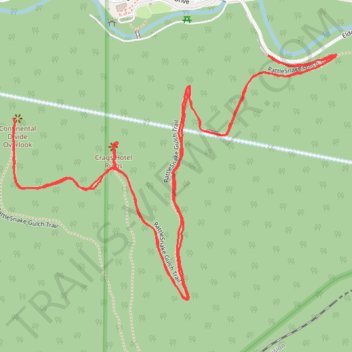
Rattlesnake Gulch Trail in Eldorado Canyon State Park
The Rattlesnake Gulch Trail in Eldorado Canyon State Park offers hikers captivating views of towering canyon walls and the serene South Boulder Creek. Midway, explorers encounter the remnants of the historic Crags Hotel, which operated in the early 1900s before succumbing to a fire. At the trail's apex, the Continental Divide Overlook provides expansive vistas of the Rocky Mountains, making the journey especially rewarding. #Hiking #Canyon #Mountain #Forest #Overlook #Nature
- Distance: 3.0 mi
- Elevation gain: 961 ft
- Maximum elevation: 6,827 ft
- Elevation loss: 965 ft
- Minimum elevation: 6,089 ft
- Moving time: 1 h 14 m
- Moving speed: 2.4 mph
- Maximum speed: 5.5 mph
- Total time: 1 h 33 m
- Global speed: 1.9 mph
Interactive trail map
Trail profile
- Distance: 3.0 mi
- Elevation gain: 961 ft
- Maximum elevation: 6,827 ft
- Elevation loss: 965 ft
- Minimum elevation: 6,089 ft
- Moving time: 1 h 14 m
- Moving speed: 2.4 mph
- Maximum speed: 5.5 mph
- Total time: 1 h 33 m
- Global speed: 1.9 mph
About this trail
Name: Rattlesnake Gulch Trail in Eldorado Canyon State Park trail, distance, elevation, map, profile, GPS track
Start: RattleSnake Gulch Trail, Boulder County, Colorado, 80025, United States (39.92943 -105.29006)
End: RattleSnake Gulch Trail, Boulder County, Colorado, 80025, United States (39.92944 -105.29004)
Coordinates: 39.92351 -105.29813 39.92952 -105.28781
Topography: Boulder County topographic map, elevation, terrain
Other hiking, mountain biking, running and outdoor activity trails
Click on a trail to view its statistics, map and profile.
Crags Hotel Ruins and Continental Divide Overlook
United States > Colorado > Boulder County
Eldorado Canyon State Park. #Hiking #Snowshoeing #Mountain #Forest #Nature
Distance: 2.9 mi • Elevation gain: 1,040 ft • Maximum elevation: 6,818 ft
New Eldorado Canyon bridge
United States > Colorado > Boulder County > Eldorado Springs
Distance: 1.9 mi • Elevation gain: 948 ft • Maximum elevation: 6,870 ft