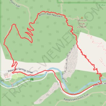
New Eldorado Canyon bridge
- Distance: 1.9 mi
- Elevation gain: 948 ft
- Maximum elevation: 6,870 ft
- Elevation loss: 928 ft
- Minimum elevation: 5,984 ft
- Moving time: 44 m 39 s
- Moving speed: 2.5 mph
- Maximum speed: 7.8 mph
- Total time: 46 m 8 s
- Global speed: 2.4 mph
Interactive trail map
Trail profile
- Distance: 1.9 mi
- Elevation gain: 948 ft
- Maximum elevation: 6,870 ft
- Elevation loss: 928 ft
- Minimum elevation: 5,984 ft
- Moving time: 44 m 39 s
- Moving speed: 2.5 mph
- Maximum speed: 7.8 mph
- Total time: 46 m 8 s
- Global speed: 2.4 mph
About this trail
Name: New Eldorado Canyon bridge trail, distance, elevation, map, profile, GPS track
Coordinates: 39.92939 -105.29485 39.93452 -105.28698
Topography: Boulder County topographic map, elevation, terrain
Other hiking, mountain biking, running and outdoor activity trails
Click on a trail to view its statistics, map and profile.
Rattlesnake Gulch Trail in Eldorado Canyon State Park
United States > Colorado > Boulder County
The Rattlesnake Gulch Trail in Eldorado Canyon State Park offers hikers captivating views of towering canyon walls and the serene South Boulder Creek. Midway, explorers encounter the remnants of the historic Crags Hotel, which operated in the early 1900s before succumbing to a fire. At the trail's apex, the…
Distance: 3.0 mi • Elevation gain: 961 ft • Maximum elevation: 6,827 ft
Eldorado Canyon Trail
United States > Colorado > Boulder County
The Eldorado Canyon Trail in Colorado offers hikers a rewarding journey through diverse terrains, beginning with a steep ascent that provides panoramic views of the canyon's towering rock formations, often dotted with climbers. As the trail progresses, it winds through shaded forests, leading to a ridge that…
Distance: 6.7 mi • Elevation gain: 2,139 ft • Maximum elevation: 7,110 ft
Crags Hotel Ruins and Continental Divide Overlook
United States > Colorado > Boulder County
Eldorado Canyon State Park. #Hiking #Snowshoeing #Mountain #Forest #Nature
Distance: 2.9 mi • Elevation gain: 1,040 ft • Maximum elevation: 6,818 ft