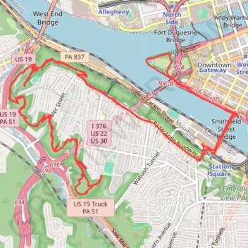
Point State to Emerald View Loop
Loop hike from Point State Park through Emerald View Park via Monongahela River, Smithfield Street Bridge, Grandview Avenue and Emerald View Trail. #Hiking #Loop #Nature #Park #River #Forest #City
- Distance: 12.3 mi
- Elevation gain: 2,497 ft
- Maximum elevation: 1,155 ft
- Elevation loss: 2,497 ft
- Minimum elevation: 696 ft
- Moving time: 4 h 2 m
- Moving speed: 3.1 mph
- Maximum speed: 14.6 mph
- Total time: 4 h 37 m
- Global speed: 2.7 mph
Interactive trail map
Trail profile
- Distance: 12.3 mi
- Elevation gain: 2,497 ft
- Maximum elevation: 1,155 ft
- Elevation loss: 2,497 ft
- Minimum elevation: 696 ft
- Moving time: 4 h 2 m
- Moving speed: 3.1 mph
- Maximum speed: 14.6 mph
- Total time: 4 h 37 m
- Global speed: 2.7 mph
About this trail
Name: Point State to Emerald View Loop trail, distance, elevation, map, profile, GPS track
Coordinates: 40.42772 -80.03225 40.44262 -80.00047
Topography: Pittsburgh topographic map, elevation, terrain
Other hiking, mountain biking, running and outdoor activity trails
Click on a trail to view its statistics, map and profile.