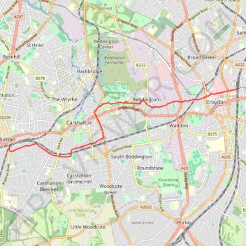
Sutton - East Croydon
Walk from Sutton to East Croydon via Beddington Park. #Walking #Hiking #City #Nature #Park
- Distance: 5.8 mi
- Elevation gain: 249 ft
- Maximum elevation: 256 ft
- Elevation loss: 249 ft
- Minimum elevation: 98 ft
- Moving time: 1 h 38 m
- Moving speed: 3.6 mph
- Maximum speed: 6.6 mph
- Total time: 1 h 40 m
- Global speed: 3.5 mph
Interactive trail map
Trail profile
- Distance: 5.8 mi
- Elevation gain: 249 ft
- Maximum elevation: 256 ft
- Elevation loss: 249 ft
- Minimum elevation: 98 ft
- Moving time: 1 h 38 m
- Moving speed: 3.6 mph
- Maximum speed: 6.6 mph
- Total time: 1 h 40 m
- Global speed: 3.5 mph
About this trail
Name: Sutton - East Croydon trail, distance, elevation, map, profile, GPS track
Coordinates: 51.35641 -0.19134 51.37478 -0.09305