Thank you for supporting this site ❤️
Make a donation
Make a donation
Gear up for your next adventure:
As an Amazon Associate, this site earns from qualifying purchases at no extra cost to you.
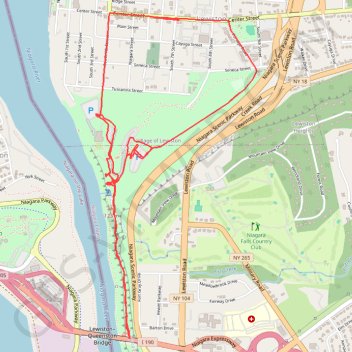
Art Park trails and random wandering
- Distance: 5.5 mi
- Elevation gain: 650 ft
- Maximum elevation: 472 ft
- Elevation loss: 607 ft
- Minimum elevation: 318 ft
- Moving time: 1 h 35 m
- Moving speed: 3.4 mph
- Maximum speed: 35.0 mph
- Total time: 2 h 46 m
- Global speed: 2.0 mph
Interactive trail map
Thank you for supporting this site ❤️
Make a donation
Make a donation
Gear up for your next adventure:
As an Amazon Associate, this site earns from qualifying purchases at no extra cost to you.
Trail profile
- Distance: 5.5 mi
- Elevation gain: 650 ft
- Maximum elevation: 472 ft
- Elevation loss: 607 ft
- Minimum elevation: 318 ft
- Moving time: 1 h 35 m
- Moving speed: 3.4 mph
- Maximum speed: 35.0 mph
- Total time: 2 h 46 m
- Global speed: 2.0 mph
Thank you for supporting this site ❤️
Make a donation
Make a donation
Gear up for your next adventure:
As an Amazon Associate, this site earns from qualifying purchases at no extra cost to you.
About this trail
Name: Art Park trails and random wandering trail, distance, elevation, map, profile, GPS track
Coordinates: 43.15284 -79.04566 43.17288 -79.03207
Topography: Niagara County topographic map, elevation, terrain
Thank you for supporting this site ❤️
Make a donation
Make a donation
Gear up for your next adventure:
As an Amazon Associate, this site earns from qualifying purchases at no extra cost to you.
Other hiking, mountain biking, running and outdoor activity trails
Click on a trail to view its statistics, map and profile.