Make a donation
Gear up for your next adventure:
As an Amazon Associate, this site earns from qualifying purchases at no extra cost to you.
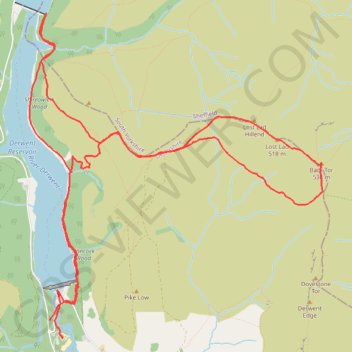
Derwent Reservoir
- Distance: 8.7 mi
- Elevation gain: 1,407 ft
- Maximum elevation: 1,732 ft
- Elevation loss: 1,457 ft
- Minimum elevation: 686 ft
- Moving time: 3 h 28 m
- Moving speed: 2.5 mph
- Maximum speed: 9.4 mph
- Total time: 4 h 28 m
- Global speed: 2.0 mph
Interactive trail map
Make a donation
Gear up for your next adventure:
As an Amazon Associate, this site earns from qualifying purchases at no extra cost to you.
Trail profile
- Distance: 8.7 mi
- Elevation gain: 1,407 ft
- Maximum elevation: 1,732 ft
- Elevation loss: 1,457 ft
- Minimum elevation: 686 ft
- Moving time: 3 h 28 m
- Moving speed: 2.5 mph
- Maximum speed: 9.4 mph
- Total time: 4 h 28 m
- Global speed: 2.0 mph
Make a donation
Gear up for your next adventure:
As an Amazon Associate, this site earns from qualifying purchases at no extra cost to you.
About this trail
Name: Derwent Reservoir trail, distance, elevation, map, profile, GPS track
Coordinates: 53.40031 -1.74618 53.42827 -1.70390
Make a donation
Gear up for your next adventure:
As an Amazon Associate, this site earns from qualifying purchases at no extra cost to you.
Other hiking, mountain biking, running and outdoor activity trails
Click on a trail to view its statistics, map and profile.
Peak District hike
United Kingdom > England > Derbyshire > High Peak > Edale > Grindsbrook Booth
Distance: 32.3 mi • Elevation gain: 4,347 ft • Maximum elevation: 2,064 ft
Peak District loop hike
United Kingdom > England > Derbyshire > High Peak > Hope
Distance: 22.6 mi • Elevation gain: 2,776 ft • Maximum elevation: 2,073 ft