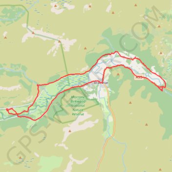
Around Braemar
- Distance: 16.5 mi
- Elevation gain: 1,027 ft
- Maximum elevation: 1,250 ft
- Elevation loss: 1,027 ft
- Minimum elevation: 1,030 ft
- Moving time: 2 h 22 m
- Moving speed: 6.9 mph
- Maximum speed: 19.8 mph
- Total time: 3 h 10 m
- Global speed: 5.2 mph
Interactive trail map
Trail profile
- Distance: 16.5 mi
- Elevation gain: 1,027 ft
- Maximum elevation: 1,250 ft
- Elevation loss: 1,027 ft
- Minimum elevation: 1,030 ft
- Moving time: 2 h 22 m
- Moving speed: 6.9 mph
- Maximum speed: 19.8 mph
- Total time: 3 h 10 m
- Global speed: 5.2 mph
About this trail
Name: Around Braemar trail, distance, elevation, map, profile, GPS track
Coordinates: 56.98620 -3.48992 57.02188 -3.33807
Other hiking, mountain biking, running and outdoor activity trails
Click on a trail to view its statistics, map and profile.
Loop eMTB Gravel: Lin of Dee -> Glen Quoich
United Kingdom > Scotland > Aberdeenshire > Claybokie
Distance: 13.2 mi • Elevation gain: 1,132 ft • Maximum elevation: 1,627 ft