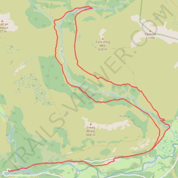
Loop eMTB Gravel: Lin of Dee -> Glen Quoich
- Distance: 13.2 mi
- Elevation gain: 1,132 ft
- Maximum elevation: 1,627 ft
- Elevation loss: 1,037 ft
- Minimum elevation: 1,079 ft
- Moving time: 2 h 40 m
- Moving speed: 4.9 mph
- Maximum speed: 16.2 mph
- Total time: 3 h 26 m
- Global speed: 3.8 mph
Interactive trail map
Trail profile
- Distance: 13.2 mi
- Elevation gain: 1,132 ft
- Maximum elevation: 1,627 ft
- Elevation loss: 1,037 ft
- Minimum elevation: 1,079 ft
- Moving time: 2 h 40 m
- Moving speed: 4.9 mph
- Maximum speed: 16.2 mph
- Total time: 3 h 26 m
- Global speed: 3.8 mph
About this trail
Name: Loop eMTB Gravel: Lin of Dee -> Glen Quoich trail, distance, elevation, map, profile, GPS track
End: Linn of Dee, C1M, Aberdeenshire, Scotland, AB35 5YB, United Kingdom (56.98957 -3.54312)
Coordinates: 56.98916 -3.54335 57.03909 -3.45370
Other hiking, mountain biking, running and outdoor activity trails
Click on a trail to view its statistics, map and profile.
Planned eMTB Gravel: Linn of Dee -> The Red House Bothy - TnB
United Kingdom > Scotland > Aberdeenshire
Following the River Dee west from the Linn of Dee
Distance: 9.5 mi • Elevation gain: 328 ft • Maximum elevation: 1,447 ft
Munro hillwalk Mheadhoin Etchachan
United Kingdom > Scotland > Aberdeenshire
Munro, hillwalk, Mheadhoin, Etchachan
Distance: 18.3 mi • Elevation gain: 5,102 ft • Maximum elevation: 4,049 ft
Munro hillwalk Chaorainn Bhreac
United Kingdom > Scotland > Aberdeenshire
Munro, hillwalk, Chaorainn, Bhreac
Distance: 13.0 mi • Elevation gain: 2,051 ft • Maximum elevation: 3,550 ft
Around Braemar
United Kingdom > Scotland > Aberdeenshire > Braemar
Distance: 16.5 mi • Elevation gain: 1,027 ft • Maximum elevation: 1,250 ft