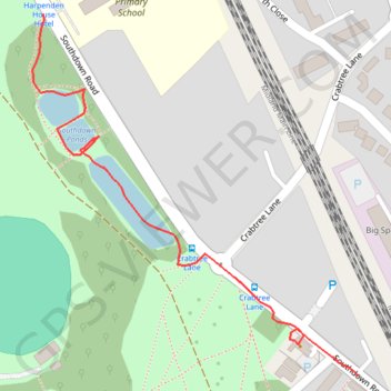
Ponds in Harpenden
- Distance: 0.4 mi
- Elevation gain: 13 ft
- Maximum elevation: 348 ft
- Elevation loss: 13 ft
- Minimum elevation: 335 ft
- Moving time: 10 m 41 s
- Moving speed: 2.4 mph
- Maximum speed: 4.4 mph
- Total time: 13 m 44 s
- Global speed: 1.9 mph
Interactive trail map
Trail profile
- Distance: 0.4 mi
- Elevation gain: 13 ft
- Maximum elevation: 348 ft
- Elevation loss: 13 ft
- Minimum elevation: 335 ft
- Moving time: 10 m 41 s
- Moving speed: 2.4 mph
- Maximum speed: 4.4 mph
- Total time: 13 m 44 s
- Global speed: 1.9 mph
About this trail
Name: Ponds in Harpenden trail, distance, elevation, map, profile, GPS track
Coordinates: 51.80848 -0.35210 51.81162 -0.34753
Other hiking, mountain biking, running and outdoor activity trails
Click on a trail to view its statistics, map and profile.
Heartwood Forest
United Kingdom > England > Hertfordshire > St Albans > Sandridge
Distance: 5.5 mi • Elevation gain: 354 ft • Maximum elevation: 417 ft