Heartwood Forest
- Distance: 5.5 mi
- Elevation gain: 354 ft
- Maximum elevation: 417 ft
- Elevation loss: 223 ft
- Minimum elevation: 282 ft
- Moving time: 43 m 55 s
- Moving speed: 7.5 mph
- Maximum speed: 21.3 mph
- Total time: 47 m 17 s
- Global speed: 7.0 mph
Interactive trail map
Trail profile
- Distance: 5.5 mi
- Elevation gain: 354 ft
- Maximum elevation: 417 ft
- Elevation loss: 223 ft
- Minimum elevation: 282 ft
- Moving time: 43 m 55 s
- Moving speed: 7.5 mph
- Maximum speed: 21.3 mph
- Total time: 47 m 17 s
- Global speed: 7.0 mph
About this trail
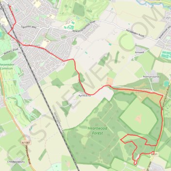
Name: Heartwood Forest trail, distance, elevation, map, profile, GPS track
Coordinates: 51.78312 -0.34944 51.81488 -0.29927
Other hiking, mountain biking, running and outdoor activity trails
Click on a trail to view its statistics, map and profile.
Ponds in Harpenden
United Kingdom > England > Hertfordshire > St Albans > Harpenden > Hatching Green
Distance: 0.4 mi • Elevation gain: 13 ft • Maximum elevation: 348 ft