Make a donation
Gear up for your next adventure:
As an Amazon Associate, this site earns from qualifying purchases at no extra cost to you.
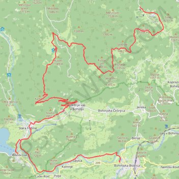
JULIANA BIKE - stage 1: Bohinjska Bistrica - Goreljek
Along the Sava Bohinjka River to Lake Bohinj and upwards to Pokljuka
- Distance: 19.7 mi
- Elevation gain: 4,042 ft
- Maximum elevation: 4,541 ft
- Elevation loss: 1,568 ft
- Minimum elevation: 1,647 ft
Interactive trail map
Make a donation
Gear up for your next adventure:
As an Amazon Associate, this site earns from qualifying purchases at no extra cost to you.
Trail profile
- Distance: 19.7 mi
- Elevation gain: 4,042 ft
- Maximum elevation: 4,541 ft
- Elevation loss: 1,568 ft
- Minimum elevation: 1,647 ft
Make a donation
Gear up for your next adventure:
As an Amazon Associate, this site earns from qualifying purchases at no extra cost to you.
About this trail
Name: JULIANA BIKE - stage 1: Bohinjska Bistrica - Goreljek trail, distance, elevation, map, profile, GPS track
Start: Triglavska cesta, Bohinjska Bistrica, Bohinj, 4264, Slovenia (46.27343 13.94957)
End: 906, Bled, Bohinj, Slovenia (46.33861 13.96181)
Coordinates: 46.26931 13.88644 46.33861 13.97592
Make a donation
Gear up for your next adventure:
As an Amazon Associate, this site earns from qualifying purchases at no extra cost to you.
Other hiking, mountain biking, running and outdoor activity trails
Click on a trail to view its statistics, map and profile.