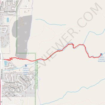
Adams Canyon Trail
Hike along North Fork of Holmes Creek to Adams Canyon Waterfall in Uinta-Wasatch-Cache National Forest #Hiking #Canyon #Forest #Waterfall #River
- Distance: 3.5 mi
- Elevation gain: 1,378 ft
- Maximum elevation: 6,220 ft
- Elevation loss: 1,378 ft
- Minimum elevation: 4,839 ft
- Moving time: 1 h 50 m
- Moving speed: 1.9 mph
- Maximum speed: 4.0 mph
- Total time: 2 h 9 m
- Global speed: 1.6 mph
Interactive trail map
Trail profile
- Distance: 3.5 mi
- Elevation gain: 1,378 ft
- Maximum elevation: 6,220 ft
- Elevation loss: 1,378 ft
- Minimum elevation: 4,839 ft
- Moving time: 1 h 50 m
- Moving speed: 1.9 mph
- Maximum speed: 4.0 mph
- Total time: 2 h 9 m
- Global speed: 1.6 mph
About this trail
Name: Adams Canyon Trail trail, distance, elevation, map, profile, GPS track
Coordinates: 41.06609 -111.90936 41.06931 -111.88523
Topography: Layton topographic map, elevation, terrain
Other hiking, mountain biking, running and outdoor activity trails
Click on a trail to view its statistics, map and profile.
Adams Canyon Trail in Uinta-Wasatch-Cache National Forest
United States > Utah > Davis County > Layton
The Adams Canyon Trail in the Uinta-Wasatch-Cache National Forest offers hikers a rewarding journey through diverse landscapes. The path begins with a series of sandy switchbacks, leading to shaded areas where the trail follows the North Fork of Holmes Creek, passing through scrub oak and majestic white pines.…
Distance: 3.5 mi • Elevation gain: 1,381 ft • Maximum elevation: 6,214 ft