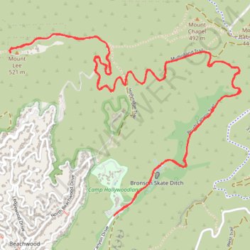
Hollywood Sign and Mount Lee
From Canyon Drive via Brush Canyon and Mulholland Trails in Griffith Park #Hike #Mountain #Forest #City
- Distance: 6.0 mi
- Elevation gain: 1,447 ft
- Maximum elevation: 1,634 ft
- Elevation loss: 1,447 ft
- Minimum elevation: 663 ft
- Moving time: 1 h 1 m
- Moving speed: 5.9 mph
- Maximum speed: 11.1 mph
- Total time: 1 h 1 m
- Global speed: 5.9 mph
Interactive trail map
Trail profile
About this trail
Name: Hollywood Sign and Mount Lee trail, distance, elevation, map, profile, GPS track
Coordinates: 34.12424 -118.32255 34.13575 -118.30488
Topography: Los Angeles topographic map, elevation, terrain
Other hiking, mountain biking, running and outdoor activity trails
Click on a trail to view its statistics, map and profile.
Hollywood Sign and Mount Lee Trail in Griffith Park
United States > California > Los Angeles County > Los Angeles
Hiking from Canyon Drive via Brush Canyon and Mulholland Trails in Griffith Park offers an immersive journey through the natural landscapes leading up to the iconic Hollywood Sign perched on Mount Lee. Along the trail, hikers are treated to panoramic vistas of Los Angeles, including sights of the Griffith…
Distance: 5.9 mi • Elevation gain: 1,417 ft • Maximum elevation: 1,634 ft
Hollywood Sign Viewpoint via Brush Canyon Trail and Mulholland Trail in Griffith Park
United States > California > Los Angeles County > Los Angeles
The Brush Canyon Trail and Mulholland Fire Road offer hikers a scenic journey through Griffith Park, culminating in a close-up view of the iconic Hollywood Sign. Along the way, hikers can enjoy panoramic vistas of Los Angeles, including downtown skyscrapers, the San Fernando Valley, and, on clear days, the…
Distance: 5.1 mi • Elevation gain: 1,243 ft • Maximum elevation: 1,276 ft
Hollywood Sign via Innsdale Trail and Mount Lee Drive in Griffith Park
United States > California > Los Angeles County > Los Angeles
The hike to the Hollywood Sign via Innsdale Trail and Mount Lee Drive offers an up-close experience with this iconic landmark, providing panoramic views of Los Angeles, the expansive Lake Hollywood Reservoir and the surrounding hills and valleys. Along the way, hikers can enjoy the natural beauty of Griffith…
Distance: 4.4 mi • Elevation gain: 978 ft • Maximum elevation: 1,631 ft
Tom LaBonge Panorama via Bill Eckert Trail and North Trail in Griffith Park
United States > California > Los Angeles County > Los Angeles
This trail to Tom LaBonge Panorama offers a moderately challenging hike in Griffith Park, winding through scenic vistas with views of Mount Hollywood, Taco Peak, and the iconic Hollywood Sign. The trail provides a rewarding panoramic perspective of Los Angeles, including landmarks like the Griffith Park Old…
Distance: 6.2 mi • Elevation gain: 1,512 ft • Maximum elevation: 1,568 ft
Wonder View Trail
United States > California > Los Angeles County > Los Angeles
Hike from Lake Hollywood to Griffith Observatory via Burbank Peak Trail, Burbank Peak, Aileen Getty Ridge Trail, Cathuenga Peak, Hugh Hefner Overlook, Mount Lee, Hollywood Sign, Mount Lee Drive, Mulholland Trail, Mount Hollywood Drive and West Observatory Road in the Griffith Park. #Hiking #Hollywood #Nature…
Distance: 5.7 mi • Elevation gain: 1,621 ft • Maximum elevation: 1,729 ft