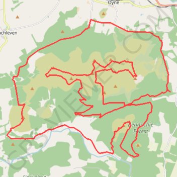
Unnamed Route
Route created on plotaroute.com
- Distance: 31.5 mi
- Elevation gain: 4,977 ft
- Maximum elevation: 1,693 ft
- Elevation loss: 4,977 ft
- Minimum elevation: 331 ft
- Moving time: 12 h 23 m
- Moving speed: 2.5 mph
- Maximum speed: 8.4 mph
- Total time: 12 h 23 m
- Global speed: 2.5 mph
Interactive trail map
Trail profile
- Distance: 31.5 mi
- Elevation gain: 4,977 ft
- Maximum elevation: 1,693 ft
- Elevation loss: 4,977 ft
- Minimum elevation: 331 ft
- Moving time: 12 h 23 m
- Moving speed: 2.5 mph
- Maximum speed: 8.4 mph
- Total time: 12 h 23 m
- Global speed: 2.5 mph
About this trail
Name: Unnamed Route trail, distance, elevation, map, profile, GPS track
Coordinates: 57.25891 -2.62464 57.31442 -2.50249
Other hiking, mountain biking, running and outdoor activity trails
Click on a trail to view its statistics, map and profile.
Huntly Castle
United Kingdom > Scotland > Moray > Dufftown
Distance: 53.6 mi • Elevation gain: 2,710 ft • Maximum elevation: 978 ft