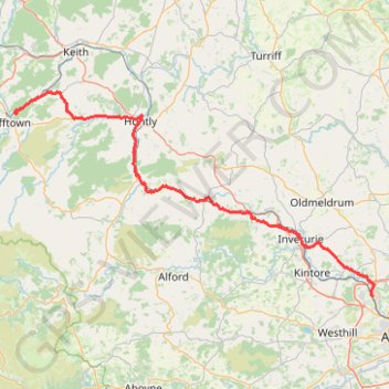
Huntly Castle
- Distance: 53.6 mi
- Elevation gain: 2,710 ft
- Maximum elevation: 978 ft
- Elevation loss: 3,235 ft
- Minimum elevation: 125 ft
- Moving time: 6 h 12 m
- Moving speed: 8.6 mph
- Maximum speed: 28.1 mph
- Total time: 9 h 15 m
- Global speed: 5.8 mph
Interactive trail map
Trail profile
- Distance: 53.6 mi
- Elevation gain: 2,710 ft
- Maximum elevation: 978 ft
- Elevation loss: 3,235 ft
- Minimum elevation: 125 ft
- Moving time: 6 h 12 m
- Moving speed: 8.6 mph
- Maximum speed: 28.1 mph
- Total time: 9 h 15 m
- Global speed: 5.8 mph
About this trail
Name: Huntly Castle trail, distance, elevation, map, profile, GPS track
Start: B9014, Dufftown, Moray, Scotland, AB55 5JR, United Kingdom (57.45819 -3.10286)
Coordinates: 57.20372 -3.10953 57.48709 -2.18391
Other hiking, mountain biking, running and outdoor activity trails
Click on a trail to view its statistics, map and profile.
Fyvie Castle and Loch of Fyvie
United Kingdom > Scotland > Aberdeenshire > Fyvie
Distance: 3.2 mi • Elevation gain: 180 ft • Maximum elevation: 220 ft
Unnamed Route
United Kingdom > Scotland > Aberdeenshire
Route created on plotaroute.com
Distance: 31.5 mi • Elevation gain: 4,977 ft • Maximum elevation: 1,693 ft