Linville Falls
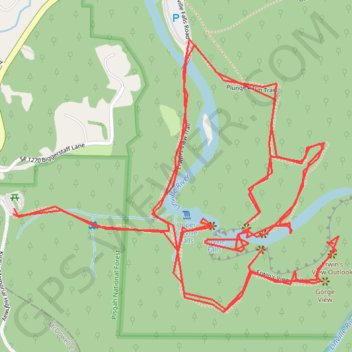
Hike from Linville Gorge Parking to Linville Falls via Erwin's View Trail, Upper Falls Overlook, Chimney View, Gorge View, Erwin's View Outlook, Linville Falls Trail, Linville River, Plunge Basin Trail, Plunge Basin Overlook and Plunge Basin in the Blue Ridge Parkway and the Pisgah National Forest. #Hiking #River #Falls #Nature #Mountain #Forest #Appalachian
- Distance: 4.9 mi
- Elevation gain: 1,355 ft
- Maximum elevation: 3,343 ft
- Elevation loss: 1,358 ft
- Minimum elevation: 3,077 ft
- Moving time: 2 h 4 m
- Moving speed: 2.3 mph
- Maximum speed: 7.3 mph
- Total time: 4 h 37 m
- Global speed: 1.0 mph
Interactive trail map
Trail profile
- Distance: 4.9 mi
- Elevation gain: 1,355 ft
- Maximum elevation: 3,343 ft
- Elevation loss: 1,358 ft
- Minimum elevation: 3,077 ft
- Moving time: 2 h 4 m
- Moving speed: 2.3 mph
- Maximum speed: 7.3 mph
- Total time: 4 h 37 m
- Global speed: 1.0 mph
About this trail
Name: Linville Falls trail, distance, elevation, map, profile, GPS track
Start: Kistler Memorial Highway, Burke County, North Carolina, 28647, United States (35.95019 -81.93343)
End: Kistler Memorial Highway, Burke County, North Carolina, 28647, United States (35.95034 -81.93340)
Coordinates: 35.94761 -81.93343 35.95478 -81.92286
Topography: Burke County topographic map, elevation, terrain
Other hiking, mountain biking, running and outdoor activity trails
Click on a trail to view its statistics, map and profile.
Comfort Suites Airport - Shady Valley Country Store
United States > Tennessee > Blount County > Alcoa > Farrport
146 mi, 2:28
Distance: 146.3 mi • Elevation gain: 10,801 ft • Maximum elevation: 3,428 ft