Maymount Park Japanese Garden Loop
- Distance: 0.9 mi
- Elevation gain: 125 ft
- Maximum elevation: 197 ft
- Elevation loss: 102 ft
- Minimum elevation: 85 ft
- Moving time: 29 m 39 s
- Moving speed: 1.8 mph
- Maximum speed: 5.3 mph
- Total time: 46 m 28 s
- Global speed: 1.1 mph
Interactive trail map
Trail profile
- Distance: 0.9 mi
- Elevation gain: 125 ft
- Maximum elevation: 197 ft
- Elevation loss: 102 ft
- Minimum elevation: 85 ft
- Moving time: 29 m 39 s
- Moving speed: 1.8 mph
- Maximum speed: 5.3 mph
- Total time: 46 m 28 s
- Global speed: 1.1 mph
About this trail
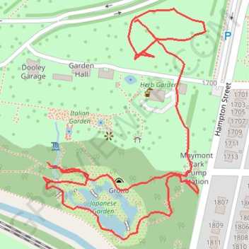
Name: Maymount Park Japanese Garden Loop trail, distance, elevation, map, profile, GPS track
End: Hampton Street, Maymont, Richmond, Virginia, 23220, United States (37.53493 -77.47574)
Coordinates: 37.53214 -77.47721 37.53509 -77.47459
Topography: Richmond topographic map, elevation, terrain
Other hiking, mountain biking, running and outdoor activity trails
Click on a trail to view its statistics, map and profile.
A bike ride in part to survey the new North Bank Trail section next to Hollywood
United States > Virginia > Richmond
Distance: 8.7 mi • Elevation gain: 591 ft • Maximum elevation: 243 ft