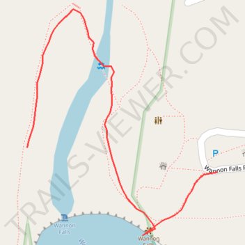
Wannon Falls
- Distance: 0.3 mi
- Elevation gain: 66 ft
- Maximum elevation: 423 ft
- Elevation loss: 39 ft
- Minimum elevation: 367 ft
- Moving time: 8 m 8 s
- Moving speed: 2.1 mph
- Maximum speed: 4.0 mph
- Total time: 18 m 47 s
- Global speed: 0.9 mph
Interactive trail map
Trail profile
- Distance: 0.3 mi
- Elevation gain: 66 ft
- Maximum elevation: 423 ft
- Elevation loss: 39 ft
- Minimum elevation: 367 ft
- Moving time: 8 m 8 s
- Moving speed: 2.1 mph
- Maximum speed: 4.0 mph
- Total time: 18 m 47 s
- Global speed: 0.9 mph
About this trail
Name: Wannon Falls trail, distance, elevation, map, profile, GPS track
Coordinates: -37.67612 141.84044 -37.67437 141.84230
Other hiking, mountain biking, running and outdoor activity trails
Click on a trail to view its statistics, map and profile.
Wannon Falls Walk
Distance: 1.5 mi • Elevation gain: 223 ft • Maximum elevation: 518 ft