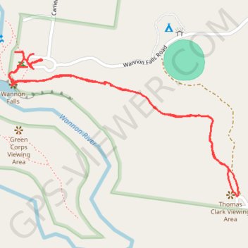
Wannon Falls Walk
- Distance: 1.5 mi
- Elevation gain: 223 ft
- Maximum elevation: 518 ft
- Elevation loss: 213 ft
- Minimum elevation: 367 ft
- Moving time: 32 m 59 s
- Moving speed: 2.7 mph
- Maximum speed: 10.5 mph
- Total time: 40 m 13 s
- Global speed: 2.2 mph
Interactive trail map
Trail profile
- Distance: 1.5 mi
- Elevation gain: 223 ft
- Maximum elevation: 518 ft
- Elevation loss: 213 ft
- Minimum elevation: 367 ft
- Moving time: 32 m 59 s
- Moving speed: 2.7 mph
- Maximum speed: 10.5 mph
- Total time: 40 m 13 s
- Global speed: 2.2 mph
About this trail
Name: Wannon Falls Walk trail, distance, elevation, map, profile, GPS track
Coordinates: -37.67913 141.84150 -37.67518 141.84940
Other hiking, mountain biking, running and outdoor activity trails
Click on a trail to view its statistics, map and profile.
Wannon Falls
Distance: 0.3 mi • Elevation gain: 66 ft • Maximum elevation: 423 ft