Dark Hollow Falls Trail in Shenandoah National Park
Dark Hollow Falls Trail in Shenandoah National Park offers a scenic hike through lush forests, taking visitors through a vibrant mix of plant life, including towering hardwoods and thick underbrush. The trail leads to the breathtaking Dark Hollow Falls, where the water cascades down a series of rocky ledges, creating a tranquil and beautiful atmosphere. Along the way, hikers can experience the sounds of rushing water, spot wildlife, and enjoy panoramic views of the valley and surrounding hills. #Hiking #Waterfall #River #Forest #Nature
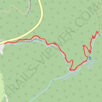
- Distance: 1.7 mi
- Elevation gain: 591 ft
- Maximum elevation: 3,428 ft
- Elevation loss: 591 ft
- Minimum elevation: 2,835 ft
- Moving time: 59 m 47 s
- Moving speed: 1.7 mph
- Maximum speed: 3.3 mph
- Total time: 1 h 14 m
- Global speed: 1.4 mph
Interactive trail map
Trail profile
- Distance: 1.7 mi
- Elevation gain: 591 ft
- Maximum elevation: 3,428 ft
- Elevation loss: 591 ft
- Minimum elevation: 2,835 ft
- Moving time: 59 m 47 s
- Moving speed: 1.7 mph
- Maximum speed: 3.3 mph
- Total time: 1 h 14 m
- Global speed: 1.4 mph
About this trail
Name: Dark Hollow Falls Trail in Shenandoah National Park trail, distance, elevation, map, profile, GPS track
Start: Dark Hollow Falls Trail, Madison County, Virginia, United States (38.51974 -78.43077)
End: Story of the Forest Trail, Big Meadows, Madison County, Virginia, United States (38.51970 -78.43086)
Coordinates: 38.51791 -78.43086 38.52057 -78.42267
Topography: Madison County topographic map, elevation, terrain
Other hiking, mountain biking, running and outdoor activity trails
Click on a trail to view its statistics, map and profile.
Rose River Loop Trail in Shenandoah National Park
United States > Virginia > Page County
The Rose River Loop Trail in Shenandoah National Park offers hikers a scenic journey alongside cascading streams and waterfalls. Starting near the Fishers Gap Overlook, the trail winds through deciduous forests, passing notable landmarks such as remnants of an old copper mine and the Cave Family Cemetery.…
Distance: 4.1 mi • Elevation gain: 955 ft • Maximum elevation: 3,061 ft
Rose River Loop Trail in Shenandoah National Park
United States > Virginia > Page County
The Rose River Loop Trail offers a delightful escape into nature, showcasing stunning scenery throughout its winding path. As you meander through tall trees and lush vegetation, you'll encounter the beautiful Rose River Falls, where the cool water cascades invitingly into a swimming hole—a perfect spot to…
Distance: 4.0 mi • Elevation gain: 978 ft • Maximum elevation: 3,064 ft
Dark Hollow Falls Trail in Shenandoah National Park
United States > Virginia > Madison County
Hiking the Dark Hollow Falls Trail offers a delightful journey through lush woodlands and alongside the soothing sounds of cascading water, culminating in breathtaking views of the impressive waterfall. As you navigate the steep, rocky paths, you’ll be rewarded with moments to pause and appreciate the beauty…
Distance: 1.7 mi • Elevation gain: 597 ft • Maximum elevation: 3,432 ft