Thank you for supporting this site ❤️
Make a donation
Make a donation
Gear up for your next adventure:
As an Amazon Associate, this site earns from qualifying purchases at no extra cost to you.
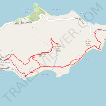
Trail near Point Udal connecting to GrapeTree
- Distance: 6.4 mi
- Elevation gain: 1,263 ft
- Maximum elevation: 607 ft
- Elevation loss: 1,211 ft
- Minimum elevation: 0 ft
- Moving time: 3 h 9 m
- Moving speed: 2.0 mph
- Maximum speed: 4.2 mph
- Total time: 4 h 8 m
- Global speed: 1.6 mph
Interactive trail map
Thank you for supporting this site ❤️
Make a donation
Make a donation
Gear up for your next adventure:
As an Amazon Associate, this site earns from qualifying purchases at no extra cost to you.
Trail profile
- Distance: 6.4 mi
- Elevation gain: 1,263 ft
- Maximum elevation: 607 ft
- Elevation loss: 1,211 ft
- Minimum elevation: 0 ft
- Moving time: 3 h 9 m
- Moving speed: 2.0 mph
- Maximum speed: 4.2 mph
- Total time: 4 h 8 m
- Global speed: 1.6 mph
Thank you for supporting this site ❤️
Make a donation
Make a donation
Gear up for your next adventure:
As an Amazon Associate, this site earns from qualifying purchases at no extra cost to you.
About this trail
Name: Trail near Point Udal connecting to GrapeTree trail, distance, elevation, map, profile, GPS track
Coordinates: 17.74560 -64.59062 17.75607 -64.56770
Topography: Saint Croix District topographic map, elevation, terrain
Thank you for supporting this site ❤️
Make a donation
Make a donation
Gear up for your next adventure:
As an Amazon Associate, this site earns from qualifying purchases at no extra cost to you.