Foel Lus
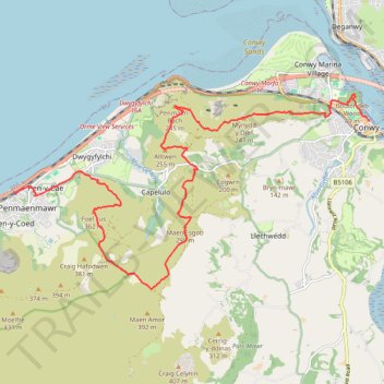
- Distance: 9.6 mi
- Elevation gain: 2,195 ft
- Maximum elevation: 1,161 ft
- Elevation loss: 2,218 ft
- Minimum elevation: 13 ft
- Moving time: 2 h 56 m
- Moving speed: 3.3 mph
- Maximum speed: 10.2 mph
- Total time: 4 h 22 m
- Global speed: 2.2 mph
Interactive trail map
Trail profile
- Distance: 9.6 mi
- Elevation gain: 2,195 ft
- Maximum elevation: 1,161 ft
- Elevation loss: 2,218 ft
- Minimum elevation: 13 ft
- Moving time: 2 h 56 m
- Moving speed: 3.3 mph
- Maximum speed: 10.2 mph
- Total time: 4 h 22 m
- Global speed: 2.2 mph
About this trail
Name: Foel Lus trail, distance, elevation, map, profile, GPS track
End: Lower Gate Street, Conwy Marina Village, Conwy, Wales, LL32 8AL, United Kingdom (53.28203 -3.82787)
Coordinates: 53.25494 -3.92358 53.28637 -3.82787
Other hiking, mountain biking, running and outdoor activity trails
Click on a trail to view its statistics, map and profile.
Back from Conwy Mountain Camp
United Kingdom > Wales > Conwy > Conwy > Conwy Marina Village
Conwy Footpaths
Distance: 5.9 mi • Elevation gain: 909 ft • Maximum elevation: 623 ft
Mynydd y Dref Loop
United Kingdom > Wales > Conwy > Conwy > Conwy Marina Village
Distance: 6.1 mi • Elevation gain: 1,066 ft • Maximum elevation: 787 ft