Thank you for supporting this site ❤️
Make a donation
Make a donation
Gear up for your next adventure:
As an Amazon Associate, this site earns from qualifying purchases at no extra cost to you.
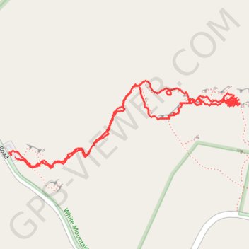
Hinterlands - White Mountain National Forest
- Distance: 1.5 mi
- Elevation gain: 627 ft
- Maximum elevation: 1,119 ft
- Elevation loss: 633 ft
- Minimum elevation: 643 ft
- Moving time: 1 h 1 m
- Moving speed: 1.5 mph
- Maximum speed: 3.1 mph
- Total time: 4 h 11 m
- Global speed: 0.4 mph
Interactive trail map
Thank you for supporting this site ❤️
Make a donation
Make a donation
Gear up for your next adventure:
As an Amazon Associate, this site earns from qualifying purchases at no extra cost to you.
Trail profile
- Distance: 1.5 mi
- Elevation gain: 627 ft
- Maximum elevation: 1,119 ft
- Elevation loss: 633 ft
- Minimum elevation: 643 ft
- Moving time: 1 h 1 m
- Moving speed: 1.5 mph
- Maximum speed: 3.1 mph
- Total time: 4 h 11 m
- Global speed: 0.4 mph
Thank you for supporting this site ❤️
Make a donation
Make a donation
Gear up for your next adventure:
As an Amazon Associate, this site earns from qualifying purchases at no extra cost to you.
About this trail
Name: Hinterlands - White Mountain National Forest trail, distance, elevation, map, profile, GPS track
Coordinates: 43.80337 -71.85076 43.80549 -71.84302
Topography: Grafton County topographic map, elevation, terrain
Thank you for supporting this site ❤️
Make a donation
Make a donation
Gear up for your next adventure:
As an Amazon Associate, this site earns from qualifying purchases at no extra cost to you.
Other hiking, mountain biking, running and outdoor activity trails
Click on a trail to view its statistics, map and profile.