Make a donation
Gear up for your next adventure:
As an Amazon Associate, this site earns from qualifying purchases at no extra cost to you.
Courtice Afternoon Ride
- Distance: 10.1 mi
- Elevation gain: 397 ft
- Maximum elevation: 446 ft
- Elevation loss: 397 ft
- Minimum elevation: 308 ft
- Moving time: 51 m 50 s
- Moving speed: 11.7 mph
- Maximum speed: 30.2 mph
- Total time: 52 m 36 s
- Global speed: 11.6 mph
Interactive trail map
Make a donation
Gear up for your next adventure:
As an Amazon Associate, this site earns from qualifying purchases at no extra cost to you.
Trail profile
- Distance: 10.1 mi
- Elevation gain: 397 ft
- Maximum elevation: 446 ft
- Elevation loss: 397 ft
- Minimum elevation: 308 ft
- Moving time: 51 m 50 s
- Moving speed: 11.7 mph
- Maximum speed: 30.2 mph
- Total time: 52 m 36 s
- Global speed: 11.6 mph
Make a donation
Gear up for your next adventure:
As an Amazon Associate, this site earns from qualifying purchases at no extra cost to you.
About this trail
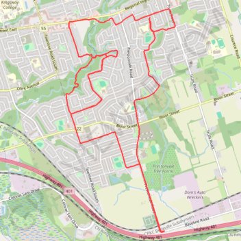
Name: Courtice Afternoon Ride trail, distance, elevation, map, profile, GPS track
Coordinates: 43.87609 -78.80858 43.90884 -78.78636
Make a donation
Gear up for your next adventure:
As an Amazon Associate, this site earns from qualifying purchases at no extra cost to you.
Other hiking, mountain biking, running and outdoor activity trails
Click on a trail to view its statistics, map and profile.
Scarborough - Cobourg
Lake Ontario. #Bike #Scarborough #Cobourg #Toronto #Ontario
Distance: 66.7 mi • Elevation gain: 2,352 ft • Maximum elevation: 427 ft
Farewell Creek Evening Walk
Canada > Ontario > Durham Region > Courtice
Distance: 3.1 mi • Elevation gain: 98 ft • Maximum elevation: 446 ft
Make a donation
Gear up for your next adventure:
As an Amazon Associate, this site earns from qualifying purchases at no extra cost to you.
Oshawa - Cobourg
Canada > Ontario > Durham Region > Oshawa
#Bike
Distance: 41.4 mi • Elevation gain: 1,486 ft • Maximum elevation: 427 ft
Farewell Creek Afternoon Hike
Canada > Ontario > Durham Region > Courtice
Distance: 4.3 mi • Elevation gain: 256 ft • Maximum elevation: 443 ft