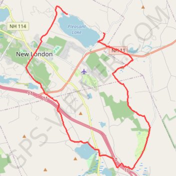
Elkins Loop / New London NH area
- Distance: 16.5 mi
- Elevation gain: 1,224 ft
- Maximum elevation: 1,286 ft
- Elevation loss: 1,220 ft
- Minimum elevation: 751 ft
- Moving time: 1 h 31 m
- Moving speed: 10.8 mph
- Maximum speed: 33.4 mph
- Total time: 1 h 39 m
- Global speed: 9.9 mph
Interactive trail map
Trail profile
- Distance: 16.5 mi
- Elevation gain: 1,224 ft
- Maximum elevation: 1,286 ft
- Elevation loss: 1,220 ft
- Minimum elevation: 751 ft
- Moving time: 1 h 31 m
- Moving speed: 10.8 mph
- Maximum speed: 33.4 mph
- Total time: 1 h 39 m
- Global speed: 9.9 mph
About this trail
Name: Elkins Loop / New London NH area trail, distance, elevation, map, profile, GPS track
Coordinates: 43.35364 -71.99119 43.43877 -71.90185
Topography: Merrimack County topographic map, elevation, terrain
Other hiking, mountain biking, running and outdoor activity trails
Click on a trail to view its statistics, map and profile.
Kearsarge Klassic 55 from Pleasant Lake
United States > New Hampshire > Merrimack County > New London > Elkins
Around Mount Kearsarge Klassic route
Distance: 57.1 mi • Elevation gain: 4,744 ft • Maximum elevation: 1,552 ft
Webb Forest Trail, Wolf Tree, Bunker and Cocoa trails loop
United States > New Hampshire > Merrimack County > New London > Elkins
Distance: 4.9 mi • Elevation gain: 791 ft • Maximum elevation: 1,483 ft
Lake Sunapee NH area
United States > New Hampshire > Merrimack County > New London > Elkins
Sunday Views NH
Distance: 33.1 mi • Elevation gain: 3,205 ft • Maximum elevation: 1,503 ft