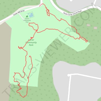
Carter community park
- Distance: 1.5 mi
- Elevation gain: 138 ft
- Maximum elevation: 1,070 ft
- Elevation loss: 210 ft
- Minimum elevation: 906 ft
- Moving time: 38 m 53 s
- Moving speed: 2.4 mph
- Maximum speed: 8.8 mph
- Total time: 40 m 7 s
- Global speed: 2.3 mph
Interactive trail map
Trail profile
- Distance: 1.5 mi
- Elevation gain: 138 ft
- Maximum elevation: 1,070 ft
- Elevation loss: 210 ft
- Minimum elevation: 906 ft
- Moving time: 38 m 53 s
- Moving speed: 2.4 mph
- Maximum speed: 8.8 mph
- Total time: 40 m 7 s
- Global speed: 2.3 mph
About this trail
Name: Carter community park trail, distance, elevation, map, profile, GPS track
Coordinates: 36.01468 -83.71670 36.02030 -83.71117
Topography: Knox County topographic map, elevation, terrain
Other hiking, mountain biking, running and outdoor activity trails
Click on a trail to view its statistics, map and profile.
Comfort Suites Airport - Shady Valley Country Store
United States > Tennessee > Blount County > Alcoa > Farrport
146 mi, 2:28
Distance: 146.3 mi • Elevation gain: 10,801 ft • Maximum elevation: 3,428 ft