Thank you for supporting this site ❤️
Make a donation
Make a donation
Gear up for your next adventure:
As an Amazon Associate, this site earns from qualifying purchases at no extra cost to you.
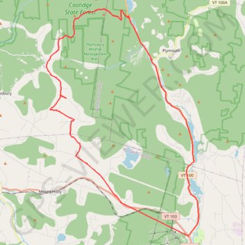
Looking for a gravel climb
- Distance: 29.6 mi
- Elevation gain: 2,953 ft
- Maximum elevation: 2,464 ft
- Elevation loss: 2,930 ft
- Minimum elevation: 1,020 ft
- Moving time: 2 h 17 m
- Moving speed: 12.9 mph
- Maximum speed: 30.8 mph
- Total time: 2 h 38 m
- Global speed: 11.2 mph
Interactive trail map
Thank you for supporting this site ❤️
Make a donation
Make a donation
Gear up for your next adventure:
As an Amazon Associate, this site earns from qualifying purchases at no extra cost to you.
Trail profile
- Distance: 29.6 mi
- Elevation gain: 2,953 ft
- Maximum elevation: 2,464 ft
- Elevation loss: 2,930 ft
- Minimum elevation: 1,020 ft
- Moving time: 2 h 17 m
- Moving speed: 12.9 mph
- Maximum speed: 30.8 mph
- Total time: 2 h 38 m
- Global speed: 11.2 mph
Thank you for supporting this site ❤️
Make a donation
Make a donation
Gear up for your next adventure:
As an Amazon Associate, this site earns from qualifying purchases at no extra cost to you.
About this trail
Name: Looking for a gravel climb trail, distance, elevation, map, profile, GPS track
Coordinates: 43.41994 -72.82864 43.56126 -72.69814
Topography: Windsor County topographic map, elevation, terrain
Thank you for supporting this site ❤️
Make a donation
Make a donation
Gear up for your next adventure:
As an Amazon Associate, this site earns from qualifying purchases at no extra cost to you.
Other hiking, mountain biking, running and outdoor activity trails
Click on a trail to view its statistics, map and profile.