2014-07-29 06:09:07 Auto
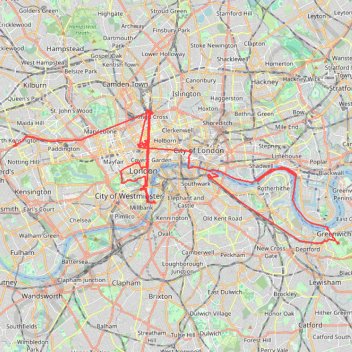
- Distance: 37.8 mi
- Elevation gain: 1,007 ft
- Maximum elevation: 125 ft
- Elevation loss: 971 ft
- Minimum elevation: -10 ft
Interactive trail map
Trail profile
- Distance: 37.8 mi
- Elevation gain: 1,007 ft
- Maximum elevation: 125 ft
- Elevation loss: 971 ft
- Minimum elevation: -10 ft
About this trail
Name: 2014-07-29 06:09:07 Auto trail, distance, elevation, map, profile, GPS track
Coordinates: 51.47770 -0.21194 51.53242 -0.00119
Other hiking, mountain biking, running and outdoor activity trails
Click on a trail to view its statistics, map and profile.
Burgess Park
United Kingdom > England > Greater London
Distance: 3.3 mi • Elevation gain: 52 ft • Maximum elevation: 20 ft
Northern Section of Green Link Walk from Epping Forest to Smithfield Market
United Kingdom > England > London
Distance: 10.9 mi • Elevation gain: 233 ft • Maximum elevation: 151 ft
Green Link Walk from Smithfield Market to end at Pekham
United Kingdom > England > City of London
Distance: 5.4 mi • Elevation gain: 135 ft • Maximum elevation: 112 ft
London Marathon
United Kingdom > England > London
Distance: 26.2 mi • Elevation gain: 922 ft • Maximum elevation: 164 ft
Night Run
United Kingdom > England > London
Distance: 6.8 mi • Elevation gain: 240 ft • Maximum elevation: 138 ft