Naar de Neus van Napoleon
<p>Deze avontuurlijke wandeling langs de Warche brengt je naar het beroemde uitzichtspunt, de Neus van Napoleon. Hoe dat uitzichtspunt aan de naam kwam ontdek je op deze route.</p>
- Distance: 8.3 mi
- Elevation gain: 1,506 ft
- Maximum elevation: 1,716 ft
- Elevation loss: 1,506 ft
- Minimum elevation: 1,220 ft
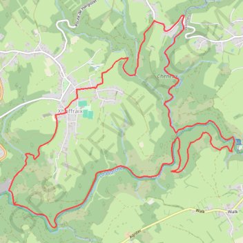
Interactive trail map
Trail profile
- Distance: 8.3 mi
- Elevation gain: 1,506 ft
- Maximum elevation: 1,716 ft
- Elevation loss: 1,506 ft
- Minimum elevation: 1,220 ft
About this trail
Name: Naar de Neus van Napoleon trail, distance, elevation, map, profile, GPS track
Coordinates: 50.44255 6.05868 50.46816 6.10135
Other hiking, mountain biking, running and outdoor activity trails
Click on a trail to view its statistics, map and profile.
GR005_Parcours-principal_2021-05-06
Netherlands > Limburg > Maastricht
GR005_Parcours-principal_2021-05-06
Distance: 205.8 mi • Elevation gain: 29,472 ft • Maximum elevation: 1,877 ft
Riethoven naar Oostenrijk
Netherlands > North Brabant > Riethoven > Eind
Distance: 573.0 mi • Elevation gain: 44,715 ft • Maximum elevation: 6,224 ft
Eurovelo 15 - Strasbourg Rotterdam
France > Grand Est > Bas-Rhin > Strasbourg
Distance: 554.1 mi • Elevation gain: 6,903 ft • Maximum elevation: 479 ft