Thank you for supporting this site ❤️
Make a donation
Make a donation
Gear up for your next adventure:
As an Amazon Associate, this site earns from qualifying purchases at no extra cost to you.
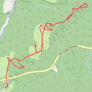
Flat Top Shortcuts
- Distance: 3.9 mi
- Elevation gain: 574 ft
- Maximum elevation: 4,518 ft
- Elevation loss: 568 ft
- Minimum elevation: 3,990 ft
- Moving time: 1 h 35 m
- Moving speed: 2.5 mph
- Maximum speed: 5.1 mph
- Total time: 2 h 4 m
- Global speed: 1.9 mph
Interactive trail map
Thank you for supporting this site ❤️
Make a donation
Make a donation
Gear up for your next adventure:
As an Amazon Associate, this site earns from qualifying purchases at no extra cost to you.
Trail profile
- Distance: 3.9 mi
- Elevation gain: 574 ft
- Maximum elevation: 4,518 ft
- Elevation loss: 568 ft
- Minimum elevation: 3,990 ft
- Moving time: 1 h 35 m
- Moving speed: 2.5 mph
- Maximum speed: 5.1 mph
- Total time: 2 h 4 m
- Global speed: 1.9 mph
Thank you for supporting this site ❤️
Make a donation
Make a donation
Gear up for your next adventure:
As an Amazon Associate, this site earns from qualifying purchases at no extra cost to you.
About this trail
Name: Flat Top Shortcuts trail, distance, elevation, map, profile, GPS track
Coordinates: 36.14977 -81.69180 36.16271 -81.67634
Topography: Watauga County topographic map, elevation, terrain
Thank you for supporting this site ❤️
Make a donation
Make a donation
Gear up for your next adventure:
As an Amazon Associate, this site earns from qualifying purchases at no extra cost to you.
Other hiking, mountain biking, running and outdoor activity trails
Click on a trail to view its statistics, map and profile.
Bass Lake Loop in Blue Ridge Parkway
United States > North Carolina > Watauga County > Blowing Rock
Distance: 4.1 mi • Elevation gain: 551 ft • Maximum elevation: 3,963 ft