Ben Shemen Hertzel Blue Single
סינגל כחול משודרג ביער בן שמן
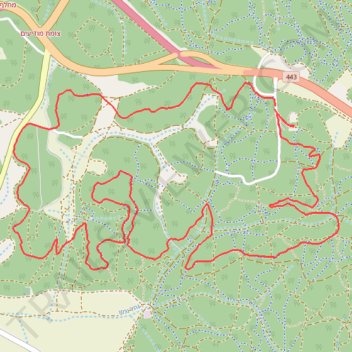
- Distance: 6.8 mi
- Elevation gain: 646 ft
- Maximum elevation: 577 ft
- Elevation loss: 646 ft
- Minimum elevation: 302 ft
- Moving time: 57 m 35 s
- Moving speed: 7.1 mph
- Maximum speed: 24.4 mph
- Total time: 58 m 58 s
- Global speed: 6.9 mph
Interactive trail map
Trail profile
- Distance: 6.8 mi
- Elevation gain: 646 ft
- Maximum elevation: 577 ft
- Elevation loss: 646 ft
- Minimum elevation: 302 ft
- Moving time: 57 m 35 s
- Moving speed: 7.1 mph
- Maximum speed: 24.4 mph
- Total time: 58 m 58 s
- Global speed: 6.9 mph
About this trail
Name: Ben Shemen Hertzel Blue Single trail, distance, elevation, map, profile, GPS track
Start: Hevel Modiin Regional Council, Ramla Subdistrict, Center District, Israel (31.95005 34.95544)
End: Hevel Modiin Regional Council, Ramla Subdistrict, Center District, Israel (31.94990 34.95542)
Coordinates: 31.94058 34.93756 31.95144 34.95980
Other hiking, mountain biking, running and outdoor activity trails
Click on a trail to view its statistics, map and profile.
מסלול חדש ומטורף. אהבתי.
Distance: 12.6 mi • Elevation gain: 932 ft • Maximum elevation: 466 ft