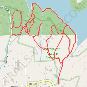
Kitchawan Nature Preserve trails
- Distance: 5.5 mi
- Elevation gain: 515 ft
- Maximum elevation: 400 ft
- Elevation loss: 515 ft
- Minimum elevation: 213 ft
- Moving time: 1 h 46 m
- Moving speed: 3.1 mph
- Maximum speed: 7.4 mph
- Total time: 1 h 57 m
- Global speed: 2.8 mph
Interactive trail map
Trail profile
- Distance: 5.5 mi
- Elevation gain: 515 ft
- Maximum elevation: 400 ft
- Elevation loss: 515 ft
- Minimum elevation: 213 ft
- Moving time: 1 h 46 m
- Moving speed: 3.1 mph
- Maximum speed: 7.4 mph
- Total time: 1 h 57 m
- Global speed: 2.8 mph
About this trail
Name: Kitchawan Nature Preserve trails trail, distance, elevation, map, profile, GPS track
Coordinates: 41.22058 -73.79472 41.23133 -73.78325
Topography: Westchester County topographic map, elevation, terrain
Other hiking, mountain biking, running and outdoor activity trails
Click on a trail to view its statistics, map and profile.