Make a donation
Gear up for your next adventure:
As an Amazon Associate, this site earns from qualifying purchases at no extra cost to you.
Bondcliff
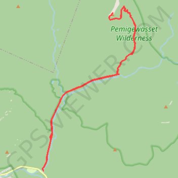
Hike from Lincoln Woods Trailhead to Bondcliff via East Branch Pemigewasset River, Lincoln Woods Trail and Bondcliff Trail in the Pemigewasset Wilderness. #Hiking #Mountain #Nature #Forest #River #Wilderness
- Distance: 18.0 mi
- Elevation gain: 3,287 ft
- Maximum elevation: 4,203 ft
- Elevation loss: 3,287 ft
- Minimum elevation: 1,158 ft
- Moving time: 8 h 3 m
- Moving speed: 2.2 mph
- Maximum speed: 4.9 mph
- Total time: 8 h 53 m
- Global speed: 2.0 mph
Interactive trail map
Make a donation
Gear up for your next adventure:
As an Amazon Associate, this site earns from qualifying purchases at no extra cost to you.
Trail profile
- Distance: 18.0 mi
- Elevation gain: 3,287 ft
- Maximum elevation: 4,203 ft
- Elevation loss: 3,287 ft
- Minimum elevation: 1,158 ft
- Moving time: 8 h 3 m
- Moving speed: 2.2 mph
- Maximum speed: 4.9 mph
- Total time: 8 h 53 m
- Global speed: 2.0 mph
Make a donation
Gear up for your next adventure:
As an Amazon Associate, this site earns from qualifying purchases at no extra cost to you.
About this trail
Name: Bondcliff trail, distance, elevation, map, profile, GPS track
Coordinates: 44.06376 -71.58863 44.14421 -71.52496
Topography: Grafton County topographic map, elevation, terrain
Make a donation
Gear up for your next adventure:
As an Amazon Associate, this site earns from qualifying purchases at no extra cost to you.
Other hiking, mountain biking, running and outdoor activity trails
Click on a trail to view its statistics, map and profile.