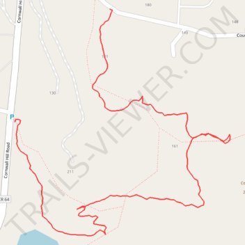
Laurel Ledges Natural Area - Cliff Trail and Sterling Farm Trail
- Distance: 1.2 mi
- Elevation gain: 325 ft
- Maximum elevation: 781 ft
- Elevation loss: 253 ft
- Minimum elevation: 482 ft
- Moving time: 30 m 22 s
- Moving speed: 2.3 mph
- Maximum speed: 4.8 mph
- Total time: 35 m 3 s
- Global speed: 2.0 mph
Interactive trail map
Trail profile
- Distance: 1.2 mi
- Elevation gain: 325 ft
- Maximum elevation: 781 ft
- Elevation loss: 253 ft
- Minimum elevation: 482 ft
- Moving time: 30 m 22 s
- Moving speed: 2.3 mph
- Maximum speed: 4.8 mph
- Total time: 35 m 3 s
- Global speed: 2.0 mph
About this trail
Name: Laurel Ledges Natural Area - Cliff Trail and Sterling Farm Trail trail, distance, elevation, map, profile, GPS track
Coordinates: 41.48222 -73.60250 41.48698 -73.59647
Topography: Putnam County topographic map, elevation, terrain
Other hiking, mountain biking, running and outdoor activity trails
Click on a trail to view its statistics, map and profile.