Make a donation
Gear up for your next adventure:
As an Amazon Associate, this site earns from qualifying purchases at no extra cost to you.
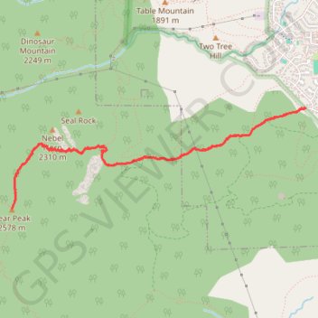
Bear Peak via Shanahan Trail and Fern Canyon Trail
The Bear Peak hike via Shanahan and Fern Canyon Trails in City of Boulder Open Space and Mountain Parks offers a challenging ascent with rewarding panoramic views. Along the way, hikers encounter a steep climb through varied terrain, including rocky paths and dense forests. Upon reaching the summit, the vistas encompass the city of Boulder, the Flatirons, and the Continental Divide. This route is well-suited for experienced hikers seeking a strenuous yet scenic adventure. #Hiking #Mountain #Forest #Nature
- Distance: 4.9 mi
- Elevation gain: 2,589 ft
- Maximum elevation: 8,350 ft
- Elevation loss: 2,589 ft
- Minimum elevation: 5,758 ft
- Moving time: 2 h 44 m
- Moving speed: 1.8 mph
- Maximum speed: 3.4 mph
- Total time: 2 h 51 m
- Global speed: 1.7 mph
Interactive trail map
Make a donation
Gear up for your next adventure:
As an Amazon Associate, this site earns from qualifying purchases at no extra cost to you.
Trail profile
- Distance: 4.9 mi
- Elevation gain: 2,589 ft
- Maximum elevation: 8,350 ft
- Elevation loss: 2,589 ft
- Minimum elevation: 5,758 ft
- Moving time: 2 h 44 m
- Moving speed: 1.8 mph
- Maximum speed: 3.4 mph
- Total time: 2 h 51 m
- Global speed: 1.7 mph
Make a donation
Gear up for your next adventure:
As an Amazon Associate, this site earns from qualifying purchases at no extra cost to you.
About this trail
Name: Bear Peak via Shanahan Trail and Fern Canyon Trail trail, distance, elevation, map, profile, GPS track
Start: Cragmoor Connector, Boulder, Boulder County, Colorado, 80305, United States (39.96864 -105.26341)
End: Cragmoor Connector, Boulder, Boulder County, Colorado, 80305, United States (39.96864 -105.26338)
Coordinates: 39.96028 -105.29521 39.96864 -105.26338
Topography: Boulder topographic map, elevation, terrain
Make a donation
Gear up for your next adventure:
As an Amazon Associate, this site earns from qualifying purchases at no extra cost to you.